
Background
Better known as planitulsa, the City’s comprehensive plan serves as a guide for the physical development of the city, other government operations, and funding priorities. Our team worked with a broad network of Tulsa residents, community organizations, City of Tulsa departments, and other subject matter experts to update the previous comprehensive plan. The update was adopted by the Planning Commission in May 2023, and approved by Tulsa City Council on June 14, 2023.
Read the Plan
Click here to download the full document, or use the links below to read individual chapters.


What’s New in this Update?
Plan Chapters
The 2010 plan had 5 chapters: Land Use, Transportation, Economic Development, Housing, and Parks, Trails, and Open Space. This update includes 10 chapters.
The Land Use, Transportation, and Economic Development chapters stayed and were updated. Housing became Housing & Neighborhoods, and the Parks, Trails, and Open Space chapter was split in two: Parks & Recreation, and Environment & Natural Resources.
We’ve also added four new chapters: the Development Review Guide; Communities; History, Culture, and Creativity; and Public Services.
Chapter 1: Development Review Guide
Everything in the comprehensive plan relevant to reviewing development proposals is contained in this chapter to make it easy for developers, the Planning Commission, City Council, residents, and others to use the plan.
Chapter 2: Future Land Use
The vision for future land use development in Tulsa is outlined in this chapter. This includes how new development occurs in relation to existing development, as well as how the development review process is conducted by the City.
Chapter 3: Transportation
This chapter consolidates the transportation planning recommendations from a variety of plans adopted since 2010. All types of transportation are covered in the chapter, as well as transportation innovations.
Chapter 4: Economic Development
This chapter contains recommendations to achieve the economic development vision of the City of Tulsa. Business retention and expansion, entrepreneurship, and economic mobility are all covered in this chapter.
Chapter 5: Housing & Neighborhoods
This chapter identifies approaches to ensure a variety of housing options at several price points are plentiful in Tulsa. Housing affordability, neighborhood characteristics, and addressing homelessness are addressed in this chapter.
Chapter 6: Communities
This chapter outlines ways the City of Tulsa and residents can engage with each other. Encouraging civic participation, building strong community partnerships, and ensuring City communications are accessible are covered in this chapter.
Chapter 7: History, Culture, & Creativity
Tulsa’s historical, cultural, and artistic environment sets it apart from other communities. This chapter identifies ways the City can support and promote these valuable community assets through programming, promotion, and funding.
Chapter 8: Parks & Recreation
Tulsa’s parks and recreation facilities are valuable community assets. This chapter outlines the vision for a successful parks system, including how to connect residents with opportunities to exercise, strengthen community, and commune with nature.
Chapter 9: Environment & Natural Resources
Tulsa’s place in Green Country comes with a wide array of environmental assets and risks. This chapter covers preparedness for flooding, pollution, energy resources, and the conservation of valuable habitat and tree canopy coverage.
Chapter 10: Public Services
This chapter compiles the planning goals for several City departments that provide services to the residents of Tulsa. It also considers the most efficient and effective ways to ensure consistent public service distribution.
Chapter Structure
Each chapter includes an introduction that explains the content of the chapter, existing conditions in Tulsa, and what we heard from the community. Next, in order to make the plan easier to use, each goal of the plan has a page in the plan, with a description of the goal and strategies to achieve the goal. Each chapter also has an Action Table, which goes into greater detail than the Goals & Strategies pages, adding a level of recommendations under each strategy.
Contexts
Each chapter of the plan also includes sections that put the subject matter into different contexts. For each chapter, metrics were identified to compare Tulsa to cities from around the United States, and over time these metrics can help evaluate Tulsa’s success in achieving the goals of the plan.
There is also a section that identifies potential considerations regarding health and wellness, social equity and resilience, funding priorities, and how Tulsa fits into the larger region.
Accessibility
Language: the entire plan will be available in Spanish, which will make it one of the first fully bilingual comprehensive plans in the entire country.
Colorblindness: We’ve also taken the time to ensure that all maps, graphs, and charts are colorblind-friendly.
Low Vision: We’ve also included alternative text for all photographs in the plan and have been testing our plan with screen readers that people with visual disabilities use in order to use computers.
Terminology: Jargon can be a barrier to understanding content in a plan, so we’ve created glossaries for each chapter of the plan, and where those terms show up in the text, we’ve turned those into links that can take you to the glossary to learn what the term means.
Development Review Guide
This guide consolidates in one place all of the information needed to understand the steps of the development review process, as well as geographically specific guidance that is considered when determining the appropriateness of a development.
Land Use Designations
To simplify review, make the process more predictable, and provide clearer distinctions between land use designations on the Land Use Map, which is referenced to determine if rezonings are appropriate, the 12 existing land use designations were consolidated to 8.
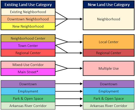
“Existing Neighborhood”, “Downtown Neighborhood”, and “New Neighborhood” were consolidated into one category – “Neighborhood”. The distinctions between “Neighborhood Center” and “Town Center” were often unclear, and the two categories now form “Local Center”; “Regional Center” remains.
“Mixed-Use Corridor” and “Main Street” were merged “Multiple Use” to reduce confusion with the City’s mixed-use zoning districts. The Major Street & Highway Plan is where streets designated as Main Street exist now, so as to apply to both the street and property along the street.
The remaining four land use designations—Downtown, Employment, Park & Open Space, and Arkansas River Corridor—remain the same.
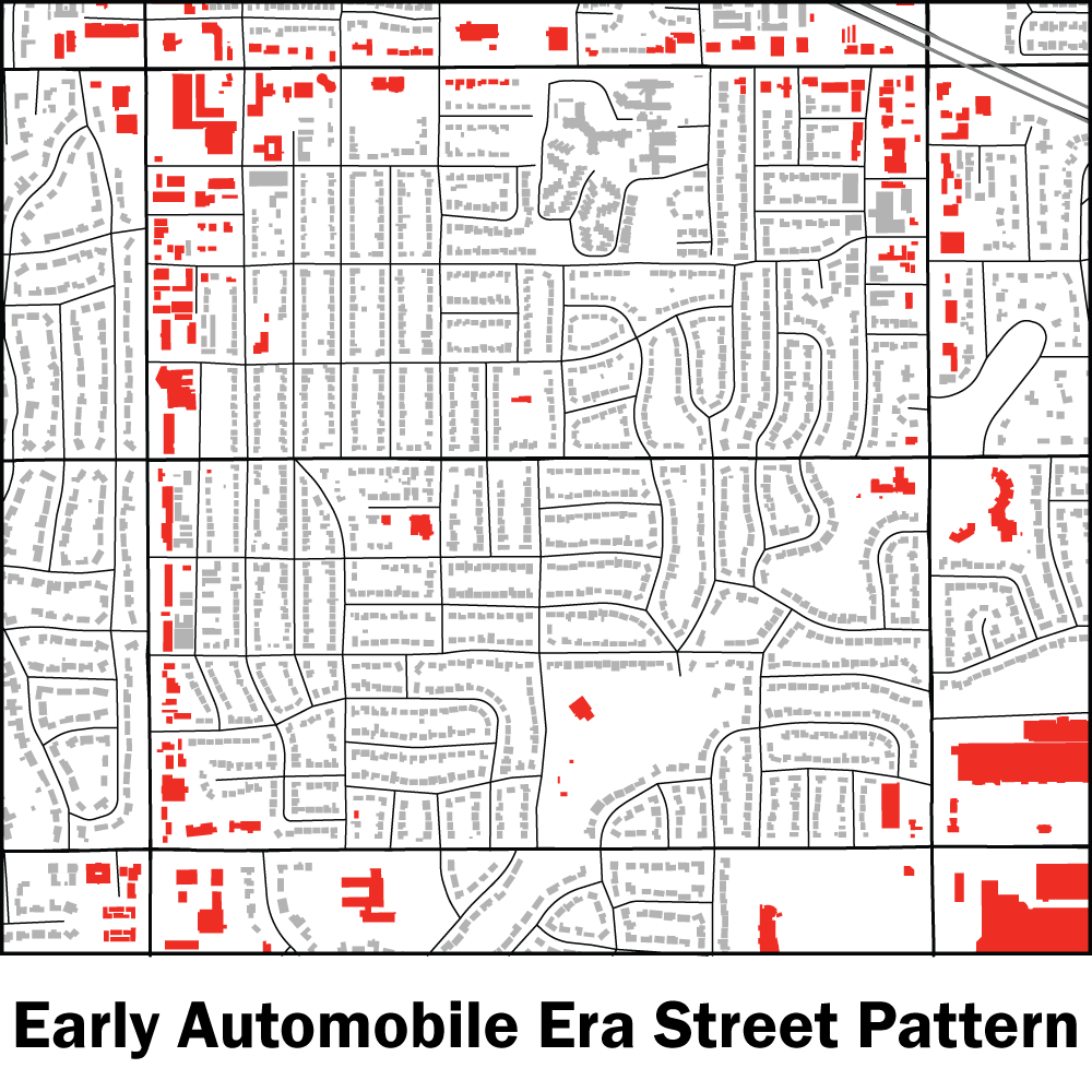
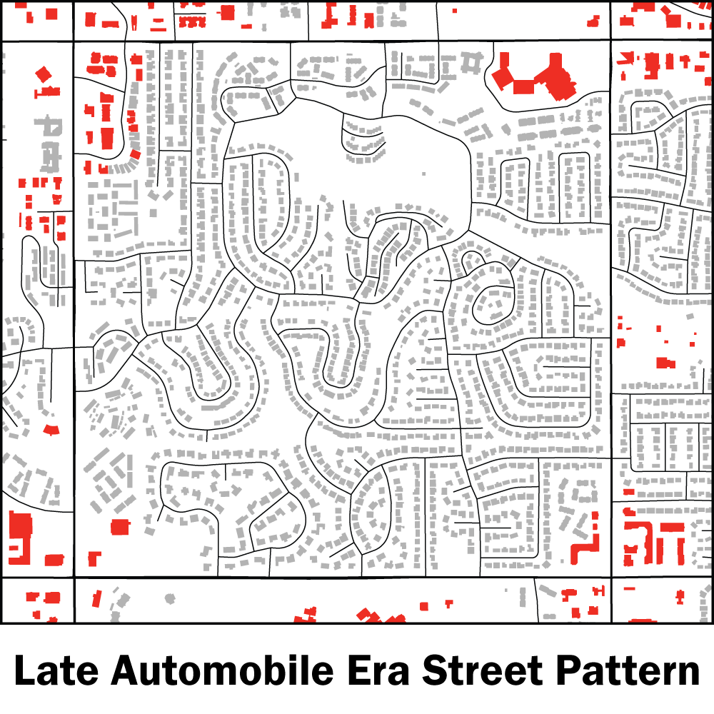
Development Era Map
We created the Development Era Map to distinguish the types of developments that are appropriate in different areas of the city based on existing characteristics of their built environment. What’s suitable for new subdivisions at the edge of the city is not necessarily what’s appropriate for infill development near downtown.
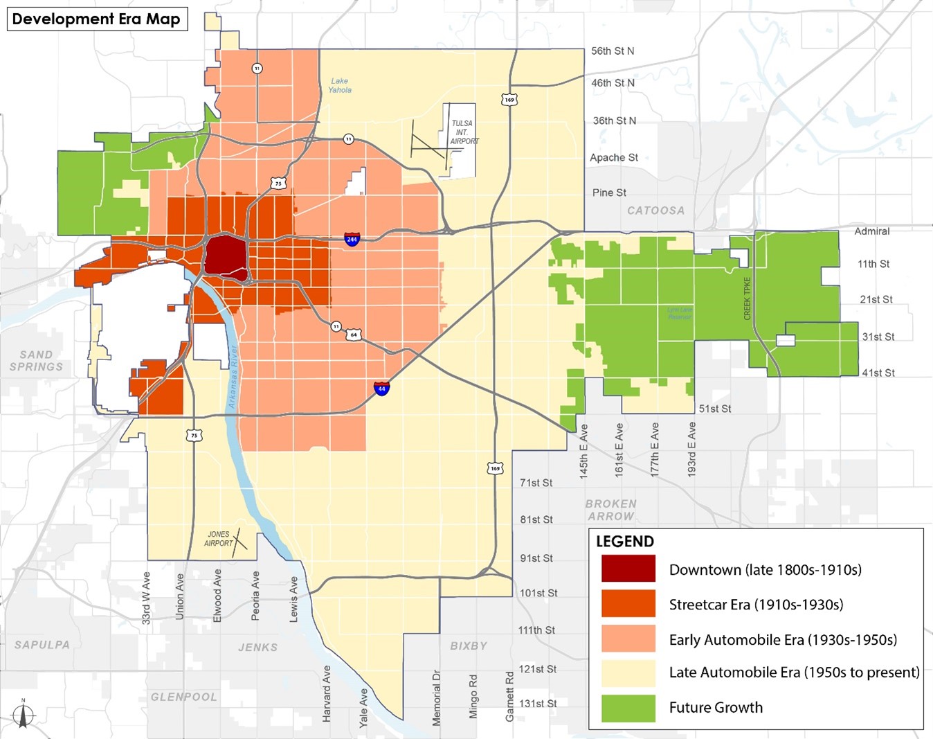
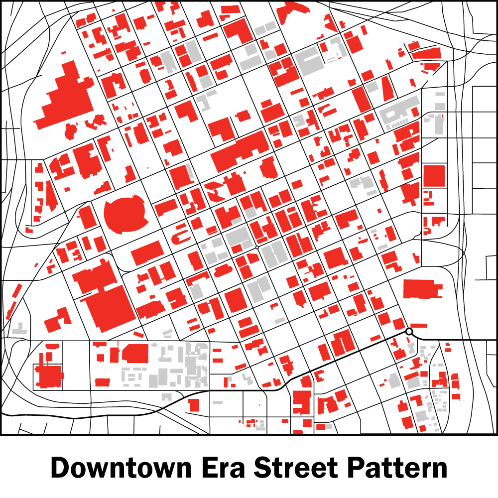
Downtown Era – The Downtown Era originally developed in the early 20th century around the Frisco railroad, prior to the introduction of a streetcar system or the proliferation of automobiles. Downtown is composed of a tight grid of straight streets and short blocks. There is a high degree of mixing residential, commercial, and mixed-use types, and strictly residential properties are generally high density.
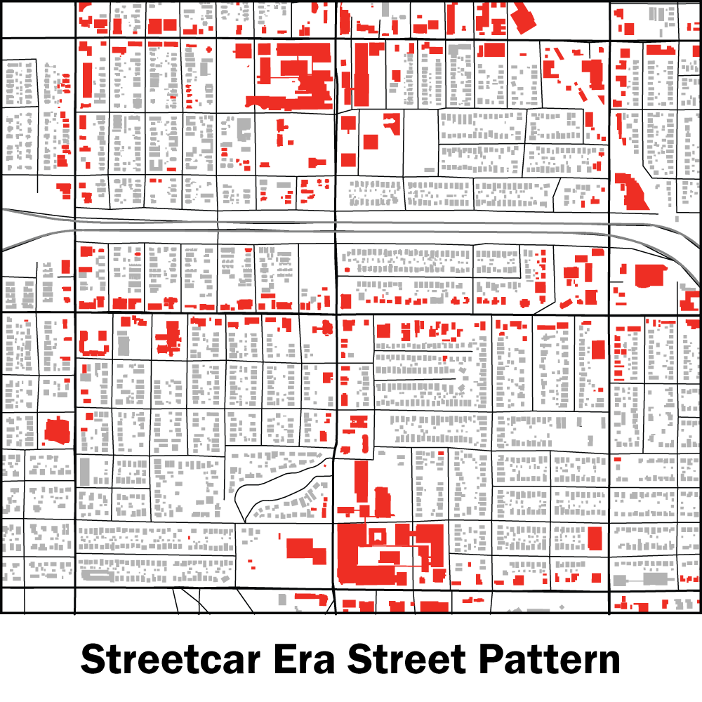
Streetcar Era – These parts of the city originally developed between the 1910s and the 1930s, facilitated by the expansion of the city’s streetcar network. This era still includes a grid of straight streets with a high degree of street connectivity, but blocks are longer and residential and non-residential uses are a bit more separated than in the previous era. Most non-residential uses exist along a half-mile grid of major streets, with some non-residential uses mixed into residential areas.
Early Automobile Era – The Early Automobile Era primarily developed during the 1930s to the 1950s. During this time, Tulsa’s land use pattern became more centered around the mile-by-mile grid of major streets. In this development era, street layout shifts from a grid of straight streets to a curvy pattern, though street connectivity remains high. Residential and non-residential uses are substantially separated, and non-residential uses are primarily oriented along linear arterial streets.
Late Automobile Era – Beginning in the late 1950s and the 1960s, major changes occurred to Tulsa’s urban form, coinciding with the introduction of the Interstate Highway System and the annexation events in the 1960s that more than doubled the land area of Tulsa. The development pattern of the Late Automobile Era is highly automobile centric, with residential areas having primarily curvy street network with a low level of street connectivity. Uses are even more separated, with non-residential uses almost exclusively located at the intersections of major arterial streets. Major streets are intended to serve as both transportation corridors and destination corridors, generating higher rates of traffic congestion.
Future Growth Areas – Areas of the city that have yet to develop designated as future growth areas lack streets beyond the mile-by-mile grid; lack adequate public services like fire, police, public and transit; have insufficient utility infrastructure like water, sewer, and broadband; and some are undeveloped due to geographic constraints such as exposed bedrock and extreme slopes.
Development Review Guide Online Tool
Our team developed an online tool that allows users to find all relevant information from the Development Review Guide for a given property by searching for an address. This can be used by anyone, but will be particularly useful for quickly evaluating properties during the development review process. The online tool provides many types of information, including: Land Use, Development Era, Zoning, Economic Development Incentives, Commercial Revitalization, Industrial Site Suitability, Tree Canopy Coverage, Flood Area, and more. → View Development Review Tool
Documents for Download
Online Development Review Tool
Frequently Asked Questions
What is this project?
The Tulsa Planning Office is updating the city’s comprehensive plan (planitulsa), which was last updated in 2010. This update includes recommendations based on input from residents, community organizations, and city departments. It also incorporates recommendations from plans developed since 2010, and enhances the usability and accessibility of the plan.
What is a comprehensive plan?
A comprehensive plan is a visionary, long‑term guide (not law) for physical development. Developers use it to guide their proposals, and the Planning Commission and City Council use it to evaluate projects.
City departments use it to plan for future needs as the city grows, like where new police and fire stations should be located. Comp plans are also used to promote the well‑being of residents, ensure the efficient use of public funds, and to help conserve natural resources.
What is in this plan?
The Comprehensive Plan includes 10 chapters covering a variety of topics.
Chapter 1: Development Review Guide
Everything in the comprehensive plan relevant to reviewing development proposals is contained in this chapter to make it easy for developers, the Planning Commission, City Council, residents, and others to use the plan.
Chapter 2: Future Land Use
The vision for future land use development in Tulsa is outlined in this chapter. This includes how new development occurs in relation to existing development, as well as how the development review process is conducted by the City.
Chapter 3: Transportation
This chapter consolidates the transportation planning recommendations from a variety of plans adopted since 2010. All types of transportation are covered in the chapter, as well as transportation innovations.
Chapter 4: Economic Development
This chapter contains recommendations to achieve the economic development vision of the City of Tulsa. Business retention and expansion, entrepreneurship, and economic mobility are all covered in this chapter.
Chapter 5: Housing & Neighborhoods
This chapter identifies approaches to ensure a variety of housing options at several price points are plentiful in Tulsa. Housing affordability, neighborhood characteristics, and addressing homelessness are addressed in this chapter.
Chapter 6: Communities
This chapter outlines ways the City of Tulsa and residents can engage with each other. Encouraging civic participation, building strong community partnerships, and ensuring City communications are accessible are covered in this chapter.
Chapter 7: History, Culture, & Creativity
Tulsa’s historical, cultural, and artistic environment sets it apart from other communities. This chapter identifies ways the City can support and promote these valuable community assets through programming, promotion, and funding.
Chapter 8: Parks & Recreation
Tulsa’s parks and recreation facilities are valuable community assets. This chapter outlines the vision for a successful parks system, including how to connect residents with opportunities to exercise, strengthen community, and commune with nature.
Chapter 9: Environment & Natural Resources
Tulsa’s place in Green Country comes with a wide array of environmental assets and risks. This chapter covers preparedness for flooding, pollution, energy resources, and the conservation of valuable habitat and tree canopy coverage.
Chapter 10: Public Services
This chapter compiles the planning goals for several City departments that provide services to the residents of Tulsa. It also considers the most efficient and effective ways to ensure consistent public service distribution.
Is this a law?
No, a comprehensive plan is not a law. It is a guide used by the City of Tulsa to help make land use decisions and achieve city departments’ priorities.
How often is it updated?
Typically, comprehensive plans are updated about once every 10 years. The last update to planitulsa was in 2010. Before that, it had been 40 years since it was updated.
Who wrote the update?
No consultants were hired for this project. A team of Tulsa Planning Office staff developed the plan and its recommendations, and has engaged with roughly 3,000 Tulsa residents, 200 organizations, and federal, tribal, state, county, and local government officials. In addition, each of the plans incorporated into this update had their own outreach efforts.
How is the plan funded?
Recommendations for infrastructure projects would likely be funded through bond issues, which are voted on by Tulsa residents. Funding for personnel, and policy and operations recommendations may come from the City’s general fund.
What was the public input process like?
In November 2022, the Tulsa Planning Office sent a bilingual post card to all 196,200 residential addresses in the City of Tulsa informing Tulsans of the plan update and the myriad ways to participate in the process.
Tulsa residents were invited to review and provide input on the draft plan update from November 2022 to March 6, 2023. Residents were able to participate in many ways: they could watch a video presentation, review the draft online and leave comments directly in the document, send an email, leave a voicemail, review printed copies at local library branches and provide written feedback there or by mail, or attend any of the eight come-and-go open houses held across the city to ensure all Tulsa residents had chance near them to participate.