Housing Zoning Code Amendments
Main Page / Citywide Changes / Neighborhood Infill Overlay
At the conclusion of the 2020 Downtown & Surrounding Neighborhood Housing Study & Strategy, staff from the Tulsa Planning Office continued meeting with community members to discuss how to address Zoning Code barriers to new housing development in Tulsa. As a result, some changes were made that apply citywide, and some changes were adopted for several neighborhoods surrounding downtown Tulsa
What did the changes do?
Both the proposed citywide zoning changes and Neighborhood Infill Overlay (limited to specific neighborhoods near downtown) promote the development new housing in Tulsa.
The citywide changes focus on lot and building regulations, reducing the lot area requirements for duplexes and cottage house developments, lot widths for duplexes and townhouses, and the required street setback in Residential-Multifamily (RM) zoning districts.
→Learn more and see the citywide changes
The Neighborhood Infill Overlay allows a greater variety of residential housing types in a manner that is compatible with the size and residential character of surrounding properties. The regulations are intended to promote housing types that accommodate households of varying sizes and income levels, and provide for a more efficient use of residential land.
→Learn more and see the overlay language
Frequently Asked Questions
What is an overlay?
In general, an overlay is a type of special zoning district. Overlay zoning is intended to be used when the base zoning district applied to an area remains generally appropriate, but when an additional, modified or eliminated requirement could help implement the city’s planning goals or address an area-specific planning, design or land use regulation issue. For more information, see Chapter 20 of the Tulsa Zoning Code.
Why is an overlay being considered for infill housing development?
In May 2020, the City of Tulsa concluded a housing market demand study and strategy for the downtown and surrounding neighborhood areas. A key recommendation of that effort was to review the Zoning Code for any potential barriers to building new housing in these existing neighborhoods. During the review, Tulsa Planning Office staff identified several potential barriers that could be addressed through the development of an overlay, including: setbacks, open space, the number of units allowed on a lot, and parking.
Who has participated in the development of the overlay?
Including outreach conducted during the Housing Study, Tulsa Planning Office staff has coordinated multiple events to collaborate with residents and neighborhood leaders in the areas where the proposed overlay would be in effect, in addition to local housing builders and architects, elected officials, and various City authorities, boards, and commissions. Public surveys were also conducted for those unable to attend scheduled meetings.
Which neighborhoods are included in the overlay boundary?
s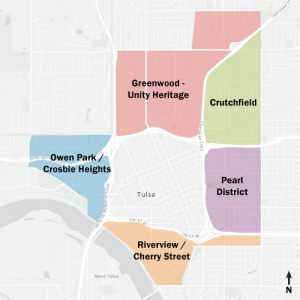 The initial focus of the proposed overlay closely align with the neighborhood areas included in the Downtown & Surrounding Neighborhoods Housing Study & Strategy. View this interactive map to see if you are included in the proposed overlay boundary.
Other neighborhoods may be added in the future where similar infill opportunities exist.
The Tulsa Planning Office staff will continue to work with the community and elected officials to identify other appropriate neighborhoods for application.
If you would like your neighborhood to be included in this overlay in the future, contact us.
Will new housing be required to match the existing housing within a neighborhood?
Unlike Historic Preservation districts, the proposed overlay will not regulate specific building styles or features such as windows, roof pitch, color, or materials. Any new housing must comply with the Zoning Code, which regulates things like building height, placement in relation to the street and adjacent properties, and the amount of required open space.
How are parking needs be addressed in areas where new homes are being built?
All new housing development still requires off-street parking spaces. Because lots in many of these older neighborhoods are constrained, the neighborhood infill overlay reduces the typical minimum off-street parking requirements by half. For example, a duplex within the overlay would require two (2) off-street parking spaces versus the minimum four (4) required in other residential neighborhoods.
How will new housing affect surrounding property values?
Property values are a product of the overall housing market, based on several factors, including location, the types of and demand for housing, neighborhood conditions, and others. New infill housing is unlikely to have a negative effect on property values because the new housing often replaces vacant lots or abandoned buildings, or involves renovating buildings, which brings stability to the neighborhood.
When did the proposed overlay go into effect?
The amendments took effect December 24, 2021.
Who can I contact for any additional information?
Nathan Foster, Principal Planner
nathanfoster@cityoftulsa.org
918-596-7609
Resources
Downtown Housing Study
2020 Housing & Neighborhoods Survey Results
Zoning Code & Small Area Plans
Amendments
Citywide Changes
Neighborhood Infill Overlay
Printable Proposed Amendments
Proposed Overlay Boundaries
Meeting Videos & Slides
Video Playlist: Neighborhood Meetings
Video: Citywide Infill Discussion
Video Playlist: Local Home Builder Roundtables
May 3, 2021 Neighborhood Meeting
• Meeting Slides
• Video Recording
May 6, 2021 Citywide Meeting
• Meeting Slides
• Video Recording
June 16, 2021 – TMAPC Hearing
• Text amendments recommended for approval
• Video Recording
August 30th – Virtual Meeting for Neighborhoods
• Video Recording
Process Timeline
July 2020 – Housing Study Released
July – Small group meetings with City Councilors
August – TMAPC Work Session to discuss Housing Study findings
August-October – Discussions and three public meetings with local home builders to discuss zoning barriers they frequently encounter when trying to build new housing in existing neighborhoods.
September – City Council initiates creation of 1) citywide text amendments to housing barriers; and 2) a Neighborhood Infill Overlay
January 2021 – Five public meetings with residents of neighborhoods surrounding downtown and their City Councilors to discuss concepts and ideas for the proposed overlay text amendments.
February-April – Test and fine-tune proposal based on real-world lot and building conditions
March – Present concepts to TMAPC at Work Session
May – Public meeting with neighborhoods surrounding downtown to present the latest draft of the proposed overlay text amendments
May – Public meeting for the citywide text amendments
June 16 – TMAPC public hearing to consider the proposed overlay and citywide text amendments
July-August – After TMAPC considers the text amendment, it will move forward to City Council for discussion and consideration. If City Council approves it, it would take effect 30-45 days later.
August – City Council initiation of a zoning map amendment to apply the new overlay to a specific area or areas.
August-September – Re-engage with residents and property owners within the proposed boundaries of the overlay.
September – TMAPC public hearing to consider the proposed overlay map amendments
September/October – After TMAPC’s recommendation (yes or no), the map amendment moved forward to the City Council for their discussion and consideration. City Council approved the map amendment, which became effective December 24, 2021.