Route 66 AERO Bus Rapid Transit (BRT)
The Route 66 AERO Bus Rapid Transit (BRT) will be Tulsa’s second BRT route providing fast and frequent bus service with enhanced vehicles, stations, and rider amenities.

![]()
![]()
![]()
![]()
![]()
Transit Service Questions & Answers
Will this BRT route have the same hours of service as the Peoria BRT, including Sundays?
Yes, the hours will be the same, and will include Sunday service.
Will the connections between this route and others (such as the Peoria AERO) be timed to ensure easy and seamless transfers?
Yes, as much as possible. Given that most of the bus routes in Tulsa are infrequent and operate on a 60-minute service, this is not always possible. However, the 15min frequency of BRT does ensure connections to the BRT from other routes are easy. Connections to the Peoria Aero will also be available.
Most bus routes only come every 60 minutes. How is this going to be fixed?
Having high frequency bus routes running East-West and North-South will improve transfers and reduce trip times system-wide. However, most routes will still be 60 mins unless morning funding for transit operations becomes available.
Can the shelters be improved to provide additional weather protection, including rain?
Yes, the project team will solicit input from riders and others on potential enhancements to shelters during the final design process in 2022. These enhancements will be included in a modified shelter design.
Southwest Blvd is part of Route 66. Can this be added to the RT66 Bus Rapid Transit route?
The route is not currently planned to extend BRT service to Southwest Boulevard, due to a lack of funding. The funding and alignment for this BRT Route were voter-approved in the Vision Tulsa (2016) and Improve Our Tulsa 2 (2018) packages.
Tulsa Transit is currently operating a reduced level of service. Will Tulsa Transit be returning to its regular bus service soon?
The reduced level of service is being caused by a driver shortage. Tulsa Transit hopes to return to regular bus service Spring 2022, but that depends on staff levels for bus operators.
Will buses and bikes share a lane?
No, the buses and bikes will not share a lane. Like all streets, there will be points where different transportation modes cross paths, but these are being reduced as much as possible. Typically, buses will pull into the bike lane to access the BRT station. In some locations with constrained right-of-way- where safety is a greater concern- the bike lane will go around the BRT station.
Can you explain how you bike lanes, parking lanes, bus traffic, and vehicular traffic will work without creating confusion or congestion along 11th St?
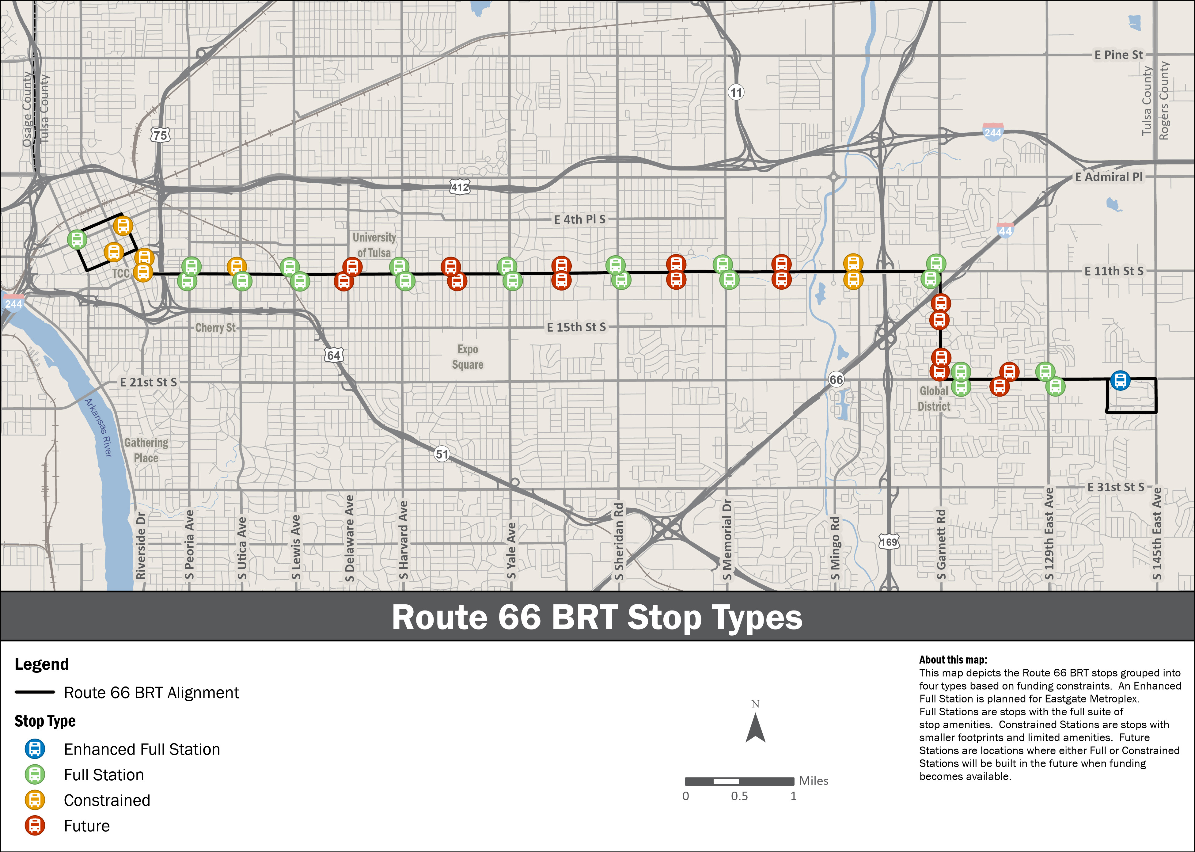
A Bus Rapid Transit (BRT) route should not have a significant effect on slowing traffic down or creating congestion. There are several reasons for this: With the BRT service, there are half the number of bus stops along the route, generally one every 1/2 mile compared to one every 1/4 mile with regular bus service. Because the station platform is level with the bus, the boarding/exiting process goes more quickly, especially for passengers using wheelchairs (which 11th has a high number of). BRT service also uses Transit Signal Priority to coordinate transit vehicles and traffic signals to reduce the time buses are stopped at traffic lights.
Route 66 is a key corridor to our city for many reasons: it’s a cultural destination, a tourist attraction, and a place of business. It is also a street that residents use to get to work, school, shop, attend faith-based activities, and for recreation. Route 66 is also thriving economically, with new developments continually being announced, and there is little indication that this will slow down any time soon. Balancing these priorities is no small task, but the street design for each area will reflect the key priorities of that area and ensure that safety is the priority. As an example, on-street parking will exist only where businesses want and need it the most. In areas with restricted right-of-way, bus-bike conflicts are being reduced by designing the bike lane to go behind the BRT station.
Will the 21st St. route (150) continue to operate separately?
Yes, the 21st St. route (150) will continue to operate separately. It’s possible the last couple of miles on the east end may be altered, but no work has been completed on this so far.
Will the 31st St. route be combined with the 21st St. route, like it was in the past (Route 221)?
When Route 221 existed, only a small portion of 31st had bus service, making it easier to combine with the 21st St. route; however, now that the 31st St. has consistent bus service from Harvard Ave. to 137th E. Ave., combining it with the 21st St. route has become a challenge for bus and driver scheduling.
Currently Route 140, the 11th St. bus route shares buses with Route 300, the 31st St. bus. Will the BRT also run on 31st St.?
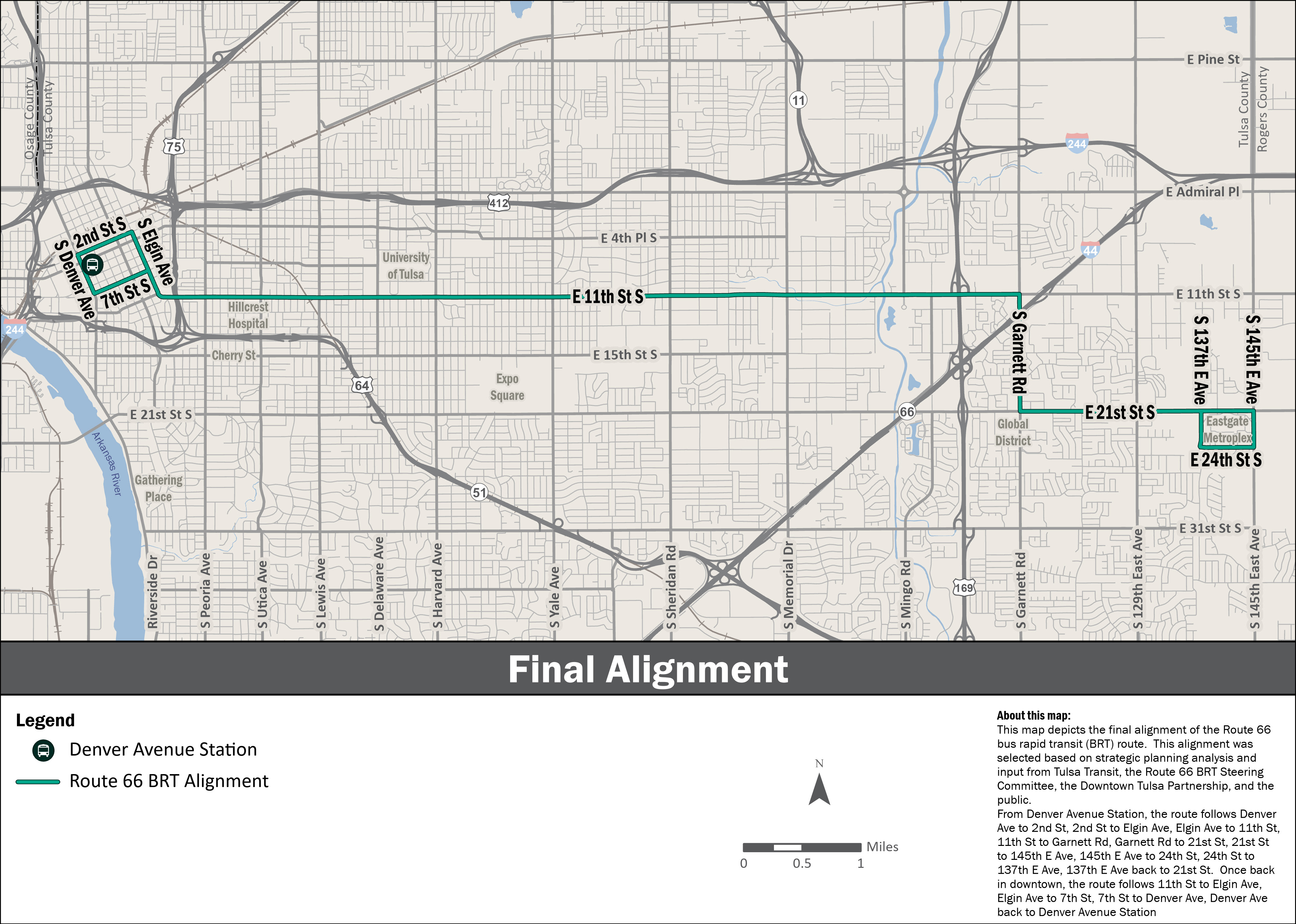
No. The BRT route will only travel between Downtown and Eastgate Metroplex, using 11th St., Garnett, and 21st St. The current bus route on 11th St. (140) will not continue to share buses with the 31st St. Route (300).
Branding & Marketing Questions & Answers
Will the Route 66 AERO BRT makers have different graphics at each station?
Every BRT station marker will include the AERO brand and logo. The Route 66 AERO BRT stations may include sub-branding elements on the maker that reflect the character of the Route 66 corridor. These elements will be consistent throughout the corridor; however, there may be opportunities to highlight major activity centers and/or key destinations such as the University of Tulsa.
Will the AERO buses be differentiated on each route? Can they be a different color for each route?
The AERO buses will incorporate the AERO branding with logo and consistent color on both the Peoria and Route 66 lines. The head sign on the front of the bus will indicate the route. The primary reason for the use of a consistent bus design is that it provides flexibility to use the same buses on both routes. If each route had unique buses, this would necessitate a sub-fleet for each line and would require additional spare vehicles.
Land Use Framework Questions & Answers
What is mixed-use zoning?
Mixed-use zoning is a type of zoning district that allows for the development of spaces and communities that have a mixture of residential, business, and retail uses, generally brings buildings closer to the sidewalk, and encourages people to walk, bicycle, or use public transit. The broad mix of uses within one building or general area can help create spaces that are easily accessible, highly walkable, and filled with multiple amenities. By applying mixed-use zoning, property owners will protect the future of their neighborhood by ensuring efficient and attractive development outcomes. The Route 66 BRT corridor will be eligible for mixed-use rezoning.
Why is mixing land uses important/beneficial?
Mixed-use zoning aims to provide both social and economic benefits by placing residential, recreational, and commercial spaces in close proximity to one another. Restricting property to a single type of use such as commercial, office, industrial, or residential significantly limits the returns on investment the property can provide to the property owner, the business owner, and the City. Neighborhoods and districts prosper when they are designed to reduce the distance between housing, workplace, retail, and other destinations. This reduction in distance provides for greater connectivity and an overall sense of place within a neighborhood, which over time, increases value.
If a property owner rezones their property to mixed-use, do they have to immediately bring their property into compliance, including setbacks, landscaping, etc.?
No. You can rezone without making changes to your site at the time of rezoning.
What are the main differences between MX districts and the base zoning districts being used today?
The most obvious difference is the flexibility in uses that may be permitted on the property. The greatest difference in application is the use of building design standards. In general, buildings in MX districts will be next to or closer to the sidewalk and street, street-facing entrances are required, parking will be behind the building, and the ground floors must include a certain amount of windows and doors that allow people on the sidewalk and people inside to see each other. The regulation of these elements ensures a consistent and connected development pattern that accommodates multiple modes of transportation and walkability.
What are the different character designations within MX zoning?
The code offers 4 separate character designations that can be determined by the context of the site being developed and the desired outcomes.
- Pedestrian
- The Pedestrian character designation is generally intended to be applied to locations where a high level of pedestrian orientation is present or desired. Pedestrian designated property will incur a build-to-zone rather than a building setback. Additionally, these designations ensure adequate transparency and ground-floor heights that complement active street life and pedestrian areas.
- Urban
- Similar to the Pedestrian designation, the Urban character designation is generally intended to apply to areas with high levels of walkability, but where a greater variety of building types are present or desired such as high-density residential or townhomes.
- Variable
- The Variable character designation is generally intended to be applied in auto-oriented areas where transitions to greater levels of walkability are underway or desired. The regulations allow greater flexibility in the sitting of buildings and parking areas, for example, allowing more generous building setbacks which can be used for landscape and streetscape elements or limited amounts of parking.
- Flexible
- The Flexible character designation is generally intended to allow the highest levels of flexibility in terms of building types and development patterns while continuing to ensure proper interaction with street-facing elements.
On-Demand Online Presentation
Contact
If you have questions about the Route 66 BRT, please contact:
Paulina Baeza — pbaeza@cityoftulsa.org